SafeSight Transforms Mining with 5G

We have the power of 5G!  SafeSight has created a 5G enabled solution that transforms both Emergency Response and Mine Rescue  as well Survey and Planning Underground. What does that mean for the industry?

Emergency Response Step Change 

Our 5G Emergency Response and Mine Rescue Technology, provides underground Emergency Response with the capability to respond from an unlimited distance under ground or from surface. Our digital technology addresses the requirements for all types of underground fire with special attention to Battery Electric Vehicles (BEV) battery fire risk management.  SafeSight 5G solutions address the industry need to respond to new risks introduced by BEV while leveraging to opportunity that 5G connectively presents for emergency response and day to day operations.

Instant Survey to Surface

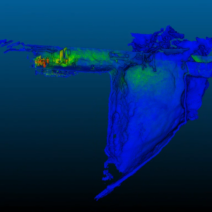
What if data from underground survey was available the moments after it was collected. Having survey data instantly available to reconciliation and planning processes would yield several significant impacts, enhancing operational efficiency, accuracy, and decision-making. Our 5G SafeScanner allows Survey and Planning to exchange 3D models from underground to surface once the data is collected. No more waiting for the data to come to surface.


“PDAC always showcases the innovation and diversity of Ontario’s mining, tech and manufacturing sectors,” said Vic Fedeli, Minister of Economic Development, Job Creation and Trade. “Our government congratulates North Bay-based SafeSight in winning the Mining Technology Innovation Challenge with its DeepTraxx and SafeScanner products, which leverage the latest 5G advances to support a safer and more efficient Ontario mining sector.”

5G Solutions

Creating operational step change

null

5G Emergency Response & Rescue

Our solutions are meant to both support and augment these evolving policies and processes. SafeSight’s 5G-DeepTraxx and 5G-SafeScanner provides underground Emergency Response a new way to plan and respond. Our Digital Tool Kit creates step change in core response processes:

  1. Remote Scene Assessment – SafeSight’s 5GDeepTraxx and 5G-SafeScanner allow for teleoperation of these solutions for the collection video, HD thermal imaging and 3D modelling of the scene.
  2. Remote Search and Rescue – HD thermal Search and LiDAR models in real time provide new data for effective planning and decision making.
  3. Increased Effective Fire Response – remote deployment of water or foam from safety decreases the incident duration and increase responder safety
  4. Leveraging Collective Intelligence – Shared data across the network allows subject matter experts from many disciplines to support responders and provide adjustments to the response plan in real time.


“Our government is proud to work with the mining sector to protect the health and safety of Ontario’s 29,000 miners, including setting the most protective limit in North America for exposure to diesel exhaust, investing in cutting-edge safety equipment, and expanding the Ontario Mine Rescue program,” said David Piccini, Minister of Labour, Immigration, Training and Skills Development. “SafeSight’s 5G-enabled Deeptraxx and SafeScanner products exemplify made-in-Ontario technologies that are keeping workers safe and driving Ontario’s world-class mining sector.”

null

Centralized Data Streams in Emergencies

Our vision for a digitally transformed Emergency Response and Mine Rescue capability started with a fundamental principle.  Responders should have digital options that supports each stage of Emergency response;

  • Incident Assessment
  • Search and Rescue
  • Evacuation to medical
  • Incident close and monitoring

The combined capability of our 5G Emergency Response DeepTraxx and our 5G-SafeScanner allowed our team to create a live stream command center view with 4 critical data feeds:

  1. Responder Captain Body Cam
  2. 3D Mapping of the Emergency
  3. HD Video of the active incident
  4. HD Thermal video of the active incident

Data drives decisions and supports collective intelligence, that keeps responders safer and brings incidents to a close in record time

null

Survey from Surface

The ability to share Survey Data as survey work is completed creates a direct impact on Reconciliation and Planning

  1. Real-time Decision-Making: Instant access to survey data allows for immediate analysis and decision-making.
  2. Improved Accuracy and Timeliness: With instant survey data availability, the accuracy of reconciliations between planned and actual outputs increases significantly.
  3. Optimized Planning Processes: Having up-to-date survey data readily accessible to planning processes ensures that mining plans are based on the most current information.


“It is great to see a company from Northern Ontario being recognized for leading the way towards an even safer future for the mining industry,” said George Pirie, Minister of Mines. “This is another great example of how the Ontario mining industry puts safety first. Thanks to Safesight for their unwavering commitment to leveraging modern technology to ensure that everyone comes home safe at the end of every shift, especially the mine rescue teams.”

Surface Emergency Command

Live Stream Video, Thermal, 3D mapping

Watch our Emergency response simulation. This 38 minute video demonstrates the power of 5G in an emergency.

The Simulation:

  1. 3 Missing workers
  2. Potential fire or BEV thermal event possible

The Incident Coordinator is able to assess the scene from surface, inform the response plan and empower responders and surface command with a full live stream of the emergency from start to finish.

DeepT & Scanner 5G#2

5G Emergency Response

SafeSight’s 5G solution activated in conjunction with the 5G infrastructure allows sites to capture immediate safety and financial ROI by allowing for transformed emergency response, remote fire response and teleoperation for search and rescue that saves lives.  The direction of Emergency Response is moving towards:

  1. Safety Zones: Specific safety zones established during BEV fire or thermal runaway incidents will ensure the safety of responders. These zones dictate safe distances (200 to 300m) where Mine Rescue Responders can operate without being at risk from potential hazards related to the incident.
  2. Avoiding Direct Engagement: Restrictions on Mine Rescue Responders directly engaging with the battery of a BEV in case of fire or thermal runaway. This precaution is to minimize the risks associated with handling high-energy battery systems and to prevent further escalation of the incident.
  3. Allowing a lithium-ion battery to burn itself out underground: Containing the fire and allowing it to burn out ensure Responder safety and containment of the incident.

Demo Scan page 3

5G Enabled Survey

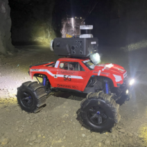
SafeSight 5G-SafeScanner and 5G-DeepTraxx remote vehicle create the capacity for Survey to collect and delivery georeferenced survey data to surface moments after the survey is completed. This allows for the immediate integration of survey into centralized platforms.  Quantifying the financial impacts of instant survey data availability on reconciliation and planning processes involves assessing various aspects influenced by improved efficiency, accuracy, and decision-making. The opportunity for financial returns will include:

  1. Cost Reductions: Calculate savings resulting from reduced downtime, improved resource utilization, and optimized operational efficiency.
  2. Improved Productivity: Measure increased production output or efficiency resulting from timely adjustments based on instant survey data.
  3. Reduction in Overheads: Assess cost savings derived from minimizing waste, better inventory management, and improved planning accuracy.
  4. Enhanced Resource Utilization: Evaluate the impact of better resource allocation and utilization on operational costs. Measure the savings from optimized use of machinery, reduced equipment downtime, and minimized idle times resulting from improved planning based on accurate survey data.
  5. Risk Mitigation and Avoidance: Quantify potential financial losses mitigated or avoided by proactively addressing geotechnical issues, safety hazards, or operational inefficiencies through immediate access to survey data.
  6. 6. Investment Return: Assess the return on investment (ROI) from the implementation of technologies or systems enabling instant survey data availability.
  7. Long-Term Benefits: Consider the long-term financial benefits of improved decision-making, better planning accuracy, and streamlined processes enabled by instant survey data availability.

5G Specifications

5G from Surface Hazardous Data Collection

Request 5G tool Set Spec Sheet

    Safesight will contact you via email with your requested Spec Sheet.

    Menu