
UNDERGROUND DRIFT SCANNING 01
Underground Drift Scanning
Map Every Metre of Development. Create Measurable As-Built Records.
SafeSight captures continuous 3D geometry through underground drifts so survey, engineering and operations teams can document what was actually developed. Create measurable as-built records for clearance, design comparison, infrastructure planning and repeat development tracking using the capture platform suited to the route.
Clearance. As-Built. Tracking.
AS-BUILT GEOMETRY
Actual development shape
CLEARANCE
Measurable available envelope
DESIGN COMPARISON
Planned vs developed
DIGITAL RECORD
Repeatable spatial history
02 As-Built Data Velocity
Development Moves Forward.
Your As-Built Data Should Keep Up.
Drifts change continuously as development advances. If spatial documentation falls behind, engineering and operations may be working from geometry that no longer represents the actual underground environment.
- Equipment clearance
- Service placement
- Ventilation
- Development progress
- Rehabilitation
- Design compliance
- Infrastructure planning
03 The Scanning Process
From Drift to Desktop.
CAPTURE / PROCESS / DELIVERCAPTURE
Move the appropriate SafeSight LiDAR configuration through the drift. Depending on access, this may include:
- Operator-carried SafeScanner
- Vehicle-mounted SafeScanner
- DeepTraxx for difficult ground access
PROCESS
Clean and geo-reference the resulting underground point cloud through the established SafeSight workflow.
DELIVER
Provide as-built spatial data ready for immediate use in survey, planning, and engineering workflows.
04 Technical Outputs
One Drift Scan.
Multiple Technical Uses.
CLEARANCE ANALYSIS
Understand the available travel envelope for mobile equipment.
DEVELOPMENT AS-BUILT
Document actual drift geometry.
DESIGN VALIDATION
Compare constructed development against mine design.
INFRASTRUCTURE
Map services and spatial relationships where visible and required.
REHABILITATION
Provide geometry for planning scaling, rehabilitation or infrastructure modifications.
CHANGE OVER TIME
Create repeated spatial records along the same development.
05 Equipment Planning
Will the Equipment Actually Fit?
Introducing larger underground equipment is not only a procurement decision.
A machine may fit on paper but still encounter:
- Utilities
- Ventilation
- Local wall irregularities
- Tight corners
- Reduced backs
- Clearance restrictions
SafeSight can compare scanned drift geometry against equipment envelopes to help identify potential interference locations before equipment deployment.
06 Published Example
From Scan to Equipment Clearance Plan
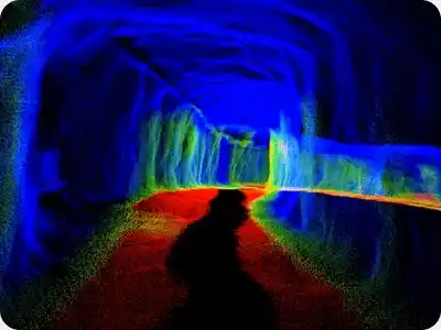
SafeSight previously documented a project approach in which in-motion LiDAR scans of ramps, drifts and shops were compared against larger-equipment envelopes to identify contact and near-contact locations.
The resulting heat-map workflow supported maintenance planning and equipment-introduction decisions.
Read Bigger Truck, More Muck →07 Capture Platforms
When Personnel or Vehicles Should Not Lead the Scan.
Where the drift is traversable but routine personnel access is restricted or undesirable, DeepTraxx can provide a ground-based remote mobility platform for SafeSight capture.
Explore DeepTraxx →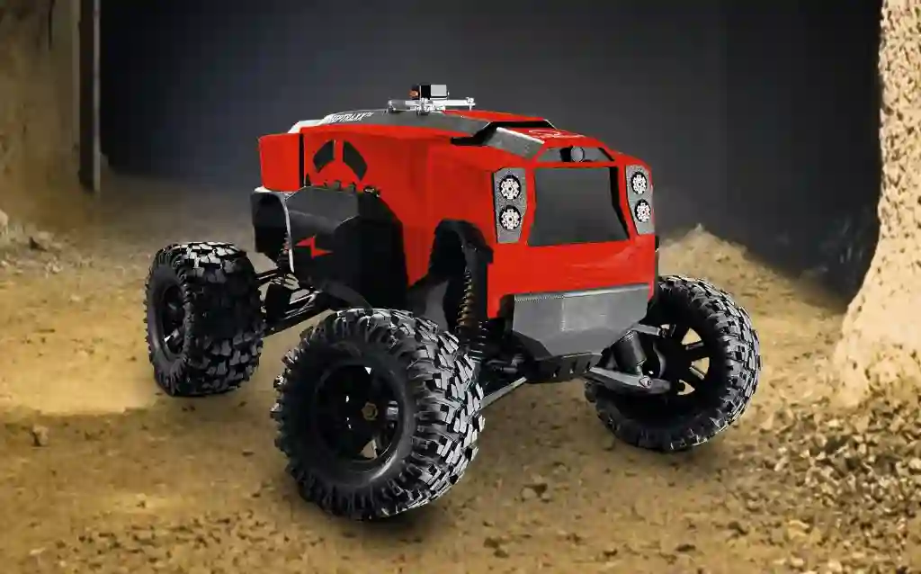
08 Capture Technology
In-Motion LiDAR for Underground Development.
SafeScanner provides the core LiDAR capture technology for compatible mobile drift-mapping configurations.
The same sensor can be deployed according to the environment rather than forcing the drift around a fixed scanning setup.
Explore SafeScanner →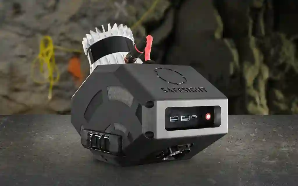
09 Software Pipeline
Capture the Drift. Process the Geometry. Keep the Record.
SAFESCANNER / DEEPTRAXX
CAPTURE
CONTROL APP
VERIFY
ECLIPSED
PROCESS
NIMBVAULT
MANAGE
ENGINEERING SOFTWARE
USE
10 Final Outputs
Drift Scanning Deliverables
Depending on project scope, SafeSight can deliver:
- Georeferenced point cloud
- 3D as-built model
- Drift cross-sections
- Clearance analysis
- Design comparison
- Equipment envelope comparison
- Heat maps
- DXF/DWG where produced
- Compatible LAS/LAZ or approved formats
- Browser visualization
Note: Final deliverables are scoped per project. We do not promise every output on every project by default.
11 Resources
Explore Drift Scanning & Mapping
Bigger Truck, More Muck
Read the project approach on comparing in-motion scans against larger equipment envelopes.
Read ArticleUnderground Mapping for Stopes, Drifts & Raises
Learn about capturing spatial data across multiple underground development types.
Read ArticleUnderground Surveying
Discover SafeSight's approach to delivering measurable geometry for mine surveying.
Read Service12 Concepts
Explore Underground Drift Scanning
What Is Underground Drift Scanning?
Underground drift scanning uses LiDAR or another spatial-data capture method to create a measurable three-dimensional record of mine development.
The resulting point cloud documents the actual shape and dimensions of the drift and can support as-built mapping, clearance studies, design comparison and infrastructure planning.
Why Scan Drifts Repeatedly?
Underground development is dynamic.
Repeated scans can provide a time-based record of development, rehabilitation and infrastructure change. The value increases when data is captured consistently and retained within the mine's broader spatial history.
Drift Scanning vs Traditional Static Survey
Static survey methods remain appropriate for many control and measurement tasks.
Mobile LiDAR becomes useful where continuous corridor geometry, large route length or repeated capture would otherwise require many individual setups.
Drift vs. Ramp Scanning
While both capture underground geometry, their operational focus differs.
Drift Scanning focuses on lateral development and localized clearance envelopes.
Ramp Scanning focuses on continuous haulage routes and route-wide equipment clearance.
Explore Ramp Scanning →13 Questions Answered
Frequently Asked Questions
01What is underground drift scanning?
Underground drift scanning uses LiDAR or another spatial-data capture method to create a measurable three-dimensional record of mine development. The resulting point cloud documents the actual shape and dimensions of the drift and can support as-built mapping, clearance studies, design comparison and infrastructure planning.
02Can drift scanning produce an as-built model?
Yes. The captured spatial data can be processed into a georeferenced point cloud or 3D as-built model representing the actual development geometry.
03Can SafeSight perform clearance analysis?
Yes. SafeSight can compare scanned drift geometry against equipment envelopes to help identify potential interference locations before equipment deployment.
04Can larger equipment be tested against a scanned drift?
Yes. In-motion LiDAR scans of ramps, drifts, and shops can be compared against larger-equipment envelopes to identify contact and near-contact locations, creating a clearance heat-map.
05Does SafeSight use DeepTraxx for every drift?
No. The capture method is selected based on the drift environment. Where personnel access is restricted, DeepTraxx can provide a ground-based remote mobility platform. Otherwise, operator-carried or vehicle-mounted SafeScanner may be used.
06Can SafeScanner be vehicle mounted?
Yes. SafeScanner provides the core LiDAR capture technology for compatible mobile drift-mapping configurations, including vehicle-mounted deployments.
07Can repeat scans show changes over time?
Yes. Repeated capture creates a time-based digital record of development, rehabilitation, and infrastructure changes along the same route.
08What formats are delivered?
Depending on project scope, deliverables can include compatible LAS/LAZ, DXF/DWG, 3D as-built models, cross-sections, and browser-viewable spatial records.
14 NEXT STEPS
How Much Underground Development Do You Need Documented?
Tell us the route length, access conditions, required outputs and current survey workflow. SafeSight will select the capture method and scope the drift scan around the decision you need to make.