Import
Bring supported underground LiDAR data into Eclipsed.
 FIELD INTELLIGENCE / ONLINE
Software Ecosystem 02
Eclipsed is SafeSight's mining-focused software for preparing underground LiDAR point clouds for survey, planning and engineering workflows.
Clean. Optimize. Align. Measure. Export.
Noise Reduction Tools
Point Density Control
Mine Grid Registration
Engineering Ready
02 Operating context / processing challenge
A high-density LiDAR scan can contain millions of spatial measurements. But raw mine data may still need:
The value of the scanner is realized only when the point cloud moves into the next technical workflow.
03 Workflow / point cloud preparation
Bring supported underground LiDAR data into Eclipsed.
Reduce unwanted static or dynamic noise and sparse scan artifacts.
Downsample large datasets according to the needs of the workflow.
Align the dataset to supported global, local or mine-specific grids.
Review point-to-point dimensions and relevant underground geometry.
Prepare supported point-cloud or model outputs for downstream software.
04 Technology / processing tools
Underground LiDAR is collected in working environments containing moving equipment, dust, moisture, and complex rock surfaces. Eclipsed includes tools designed to reduce unwanted static or dynamic noise and sparse returns from the core geometry.
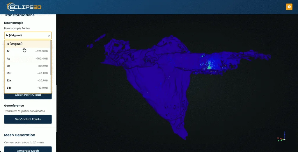
A high-resolution point cloud provides excellent detail, but not every downstream engineering task requires millions of points. Eclipsed allows technical teams to downsample and optimize the dataset so it becomes manageable without sacrificing spatial fidelity.
A scan floating in an arbitrary coordinate system cannot be accurately compared against mine designs. Eclipsed provides geo-referencing capabilities to align scans based on established reference points so the resulting data matches the local grid.
Verify dimensions directly within the point cloud. Pull point-to-point measurements to evaluate headings, infrastructure clearances and as-built geometry before committing the data to export.
05 Visual output / clear geometry
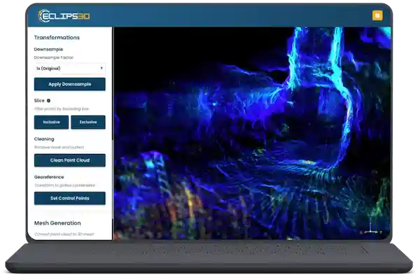
Visualizing the raw dataset is just the start. This real SafeSight product visual shows point-cloud data moving through the Eclipsed processing workflow.
As noise and sparse points are removed, the required geometry—drifts, raises, or stopes—becomes clearly defined and ready for the next technical step.
06 Field applications / engineering use
Prepare cavity geometry for reconciliation and technical analysis.
Clean and prepare long mobile-mapping datasets.
Process dense vertical geometry for shaft-specific engineering workflows.
Learn about shaft inspection →Prepare spatial data captured from specialized vertical inspection systems.
Standardize repeated scans as underground development advances.
07 Data handover / software integration
Eclipsed is intended to prepare mine spatial data for use in established planning, geology and engineering systems rather than locking the dataset into a proprietary format.
The current specifications list LAS, LAZ, PLY and XYZ. Verify supported output formats and confirm production release before publication based on your downstream workflow.
The Control App helps the field operator understand the scan while capture is taking place. Eclipsed begins once detailed processing is required.
Eclipsed prepares spatial data. NimbVault manages the resulting mine data across sites, levels, areas, drifts and time periods. Once processing is complete, NimbVault can become the persistent home for the mine's spatial record.
08 Technical definitions / questions answered
Mining point cloud software helps technical teams prepare and work with three-dimensional spatial data captured throughout a mine.
Mine LiDAR datasets may require cleaning, optimization, coordinate alignment, measurement or conversion before they can enter planning, geology and engineering workflows.
Mining-focused software differs from generic point-cloud tools by placing those functions within the context of mine grids, underground geometry and established mine technical systems.
Underground LiDAR is collected in working environments that can contain dust, moisture, infrastructure, moving equipment and complex surfaces.
These conditions can introduce unwanted points or irrelevant geometry. Cleaning helps isolate the surfaces required for technical analysis.
Geo-referencing places captured spatial information into a known coordinate framework. In mining, this often means aligning an underground point cloud to the site's established mine grid so captured geometry can be compared with designs and other survey information.
High-density LiDAR can produce extremely large datasets. Downsampling reduces point count where appropriate so the information can become easier to manage or transfer into downstream software. The level of reduction should be based on the technical requirement, not simply on creating the smallest possible file.
For teams comparing broader point cloud processing software, SafeSight is developing additional technical resources covering workflows beyond mining-specific applications.
Eclipsed is SafeSight's mining point-cloud software for cleaning, optimizing, geo-referencing, measuring and preparing underground LiDAR data.
Current Eclipsed specifications include automated static and dynamic noise-reduction tools.
Yes. Eclipsed includes point-cloud optimization and downsampling capabilities for compatible datasets.
Current specifications include global, local and mine-specific grid support.
Current specifications include point-to-point measurement tools.
Eclipsed is positioned primarily around SafeSight's mining and underground spatial-data workflows. SafeSight will provide broader point-cloud processing resources separately.
No. Eclipsed prepares spatial data for downstream use. Mine planning, geology and engineering platforms continue to perform their specialized functions.
09 / WORKFLOW REVIEW
If your field capture is fast but mine point-cloud preparation still requires repetitive cleanup, coordinate work and file conversion, show SafeSight the process.
We will review how Eclipsed could fit between your capture systems and your technical software.