
Mine
Root level spatial asset organization.
 FIELD INTELLIGENCE / ONLINE
Software Ecosystem 03
NimbVault is SafeSight's secure cloud-based environment for organizing, viewing and managing underground spatial data across mine sites, levels, areas, drifts and time periods.
Organize. Visualize. Track. Access. Manage.
Mine / Level / Drift
3D Visualization
Time-Series History
Role-Based Security
02 Operating context / data challenge
Underground spatial information can become scattered across:
Months later, the challenge may not be collecting another scan. The challenge is knowing: Which dataset is current? Where is the previous scan? Who captured it? What area does it represent? Which version should engineering use?
03 Workflow / data organization
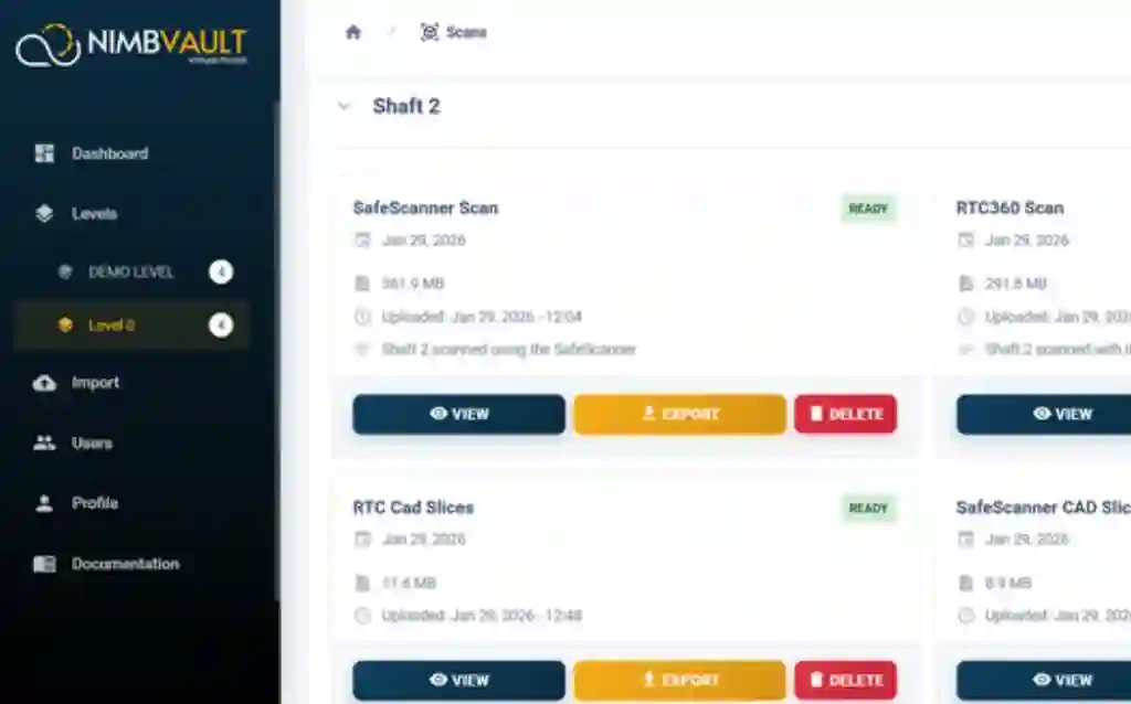
NimbVault structures underground spatial information according to physical mine hierarchy rather than generic computer folders. Users can move through the mine logically and locate the spatial records associated with the area they are working on.
Root level spatial asset organization.
Vertical or horizontal sub-division.
Specific operational zones.
Specific underground headings.
Version-controlled spatial record.
04 Technology / management tools
Give survey, engineering, planning, operations, and management a shared spatial reference rather than creating another copy of the same dataset for every department.
NimbVault should not be positioned as another generic file-storage service. Its value comes from combining mine hierarchy, spatial visualization, measurement, permissions, metadata, and versioning.
Once spatial data is organized consistently, repeat capture becomes more valuable. Retain previous datasets alongside newer information to support development history, stope progression, and historical engineering reference.
Built around role-based access and multi-factor authentication with secure cloud architecture rather than simply sharing raw files.
Centralized technical teams can review spatial assets across operations while site-level teams work with their own levels, areas, and drifts.
05 Visual access / browser tools
NimbVault includes a browser-optimized high-density point-cloud viewer so authorized users can inspect 3D mine data without requiring every stakeholder to install specialist desktop software.
Measure mine geometry where the data lives. This provides immediate context for engineering and planning teams but does not replace certified survey workflows.
06 Field applications / stakeholders
Store and organize repeat drift scans.
Keep processed cavity geometry connected to the correct area and time period.
Build a long-term spatial record of shaft measurements and scans.
Organize mine asset and spatial records according to location.
Locate scans, review geometry and access processed underground data without waiting for manual file transfers.
Reference current and historical spatial information alongside mine planning and technical analysis workflows.
Review spatial context and gain visibility across approved mine sites without requiring specialist desktop software.
07 Data handover / software integration
The current specification supports exporting spatial data when your downstream engineering tools require it. Supported Exports: LAS, LAZ, PLY, CSV.
The Control App begins the digital workflow at capture. NimbVault completes the information lifecycle by giving the resulting mine data a structured, accessible historical home.
Eclipsed prepares the underground point cloud. NimbVault gives that processed dataset a permanent location inside the mine's digital hierarchy.
08 Technical definitions / questions answered
Mine data management software organizes technical information so it can be located, governed and reused throughout mining operations.
For spatial mine data, this can include: LiDAR point clouds; 3D geometry; mine locations; scan dates; versions; metadata; measurements; and access permissions.
The purpose is not simply storing more files. It is maintaining enough structure and context that the correct information can be found and understood later.
Underground mines change continuously. Development advances, stopes are mined, infrastructure changes and new scans replace old representations.
Without clear version history, different teams can unintentionally work from different spatial datasets. Version-controlled mine data creates a traceable record of what was captured and when.
Specialist desktop point-cloud tools remain important for technical processing. But not every person who needs to understand mine geometry needs to perform advanced point-cloud processing. Browser visualization allows authorized stakeholders to review 3D information without requiring every user to maintain the same specialist software environment.
Point-cloud processing changes or prepares the spatial dataset. Mine data management organizes that information after processing.
Within SafeSight: Eclipsed = PROCESS, NimbVault = MANAGE.
A connected digital spatial record builds a comprehensive 3D mine record or mine digital twin over time.
NimbVault is SafeSight's secure cloud-based mine data management software for organizing, visualizing and retaining underground spatial information.
Current specifications organize data through a hierarchy including Mine → Level → Area → Drift.
Yes. Current specifications include a browser-optimized point-cloud viewer.
Current specifications include browser measurement tools for supported dimensions including width, height and clearance.
Current product documentation includes automated versioning and time-series records. Specific metadata availability depends on the current production configuration.
No. Eclipsed processes mine point-cloud data. NimbVault organizes, visualizes and manages the resulting datasets.
No. NimbVault is SafeSight's spatial mine-data management software. The separate SafeSight customer portal serves a different customer-account workflow and is not part of NimbVault.
Current SafeSight product documentation describes multi-site management for centralized and site-level technical teams. Availability should be confirmed for the intended deployment.
Current specifications include secure cloud deployment, multi-factor authentication and role-based permissions. Security capabilities should be reviewed against the intended deployment requirements.
11 / WORKFLOW REVIEW
If point clouds are currently stored across individual computers, project folders and disconnected file systems, the issue is no longer only data capture. It is finding the right information when someone needs it.
Show SafeSight how your mine currently stores spatial data and we will review whether NimbVault fits the workflow.